Showing posts with label AUSTRALIA. Show all posts

Wednesday, September 28, 2011

Kakadu National Parkin Australia

Kakadu National Park is in the Northern Territory of Australia, 171 km southeast of Darwin.
Kakadu National Park is located within the Alligator Rivers Region of the Northern Territory of Australia. It covers an area of 19,804 km2 (7,646 sq mi), extending nearly 200 kilometres from north to south and over 100 kilometres from east to west. It is the size of Slovenia, about one-third the size of Tasmania, or nearly half the size of Switzerland. The Ranger Uranium Mine, one of the most productive Uranium mines in the world, is contained within the park.

History

Prologue

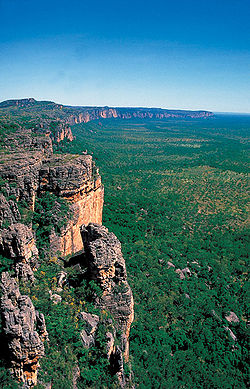
The name Kakadu comes from the mispronunciation of ‘Gagadju’ which is the name of an Aboriginal language spoken in the northern part of the Park. Kakadu is ecologically and biologically diverse. The main natural features protected within the National Park include:
  • four major river systems:
    • the East Alligator River,
    • the West Alligator River,
    • the Wildman River; and
    • the entire South Alligator River;
  • six major landforms
    • estuaries and tidal flats,
    • floodplains,
    • lowlands,
    • the stone country,
    • the outliers; and
    • the southern hills and basins;
  • a remarkable variety and concentration of wildlife;
    • over 280 bird species
    • roughly 60 mammal species
    • over 50 freshwater species
    • over 10 000 insects species
    • over 1600 plant species.
Aboriginal people have occupied the Kakadu area continuously for at least 40 000 years. Kakadu National Park is renowned for the richness of its Aboriginal cultural sites. There are more than 5000 recorded art sites illustrating Aboriginal culture over thousands of years. The archaeological sites demonstrate Aboriginal occupation for at least 20 000 and possibly up to 40 000 years.
Kakadu wetlands
The cultural and natural values of Kakadu National Park were recognised internationally when the Park was placed on the UNESCO World Heritage List. This is an international register of properties that are recognised as having outstanding cultural or natural values of international significance. Kakadu was listed in three stages: Stage 1 in 1981, Stage 2 in 1987, and the entire Park in 1992.
Approximately half of the land in Kakadu is aboriginal land under the Aboriginal Land Rights (Northern Territory) Act 1976 and most of the remaining land is currently under claim by Aboriginal people. The areas of the Park that are owned by Aboriginal people are leased by the traditional owners to the Director of National Parks to be managed as a national park. The remaining area is Commonwealth land vested under the Director of National Parks. All of Kakadu is declared a national park under the Environment Protection and Biodiversity Conservation Act 1999.
The Aboriginal traditional owners of the Park are descendants of various clan groups from the Kakadu area and have longstanding affiliations with this country. Their lifestyle has changed in recent years, but their traditional customs and beliefs remain very important. About 500 Aboriginal people live in the Park; many of them are traditional owners. All of Kakadu is jointly managed by Aboriginal traditional owners and the Australian Government’s Department of the Environment and Water Resources through a division known as Parks Australia. Park Management is directed by the Kakadu Board of Management

Tourism

The Crocodile Hotel at Jabiru
Kakadu National Park is a major tourist attraction in Australia’s north. Visitation in 2005 was 202,000. Kakadu’s dramatic landscape, Aboriginal cultural significance and diverse and abundant wildlife are what visitors are drawn to. There are many beautiful waterfalls and gorges within the Park that are popular with visitors such as Maguk, Gunlom, Twin Falls and Jim Jim Falls.
Kakadu National Park has some of the best examples of Aboriginal rock art in Australia. The sites of Nourlangie and Ubirr are among the most visited locations in the Park. It is possible to view some of Kakadu’s diverse wildlife at places like Yellow Water Billabong, Cooinda on board a wildlife cruise or at Mamukala Wetlands or Anbangbang Billabong. The Kakadu region is one of the world’s best for bird watching as approximately 30 percent of Australia’s bird species can be seen here.
No swimming sign
Large saltwater crocodiles are also commonplace and visitors are likely to see them at Yellow Water and East Alligator River so it was no coincidence that the Crocodile Dundee films were shot here. Visitors are urged to exercise caution around crocodiles as they have been responsible for a number of fatal attacks. Recreational fishing is a popular activity inside Kakadu National Park. The main target species is Barramundi and the most popular locations are Yellow Water, the South Alligator and the East Alligator River. Hunting is not allowed in Kakadu National Park.
There are several accommodation options in the Park, mostly found in the town of Jabiru, as well as a range of services to cater to visitor’s needs. Visitors can experience Kakadu National Park with a recognised tour operator or they can drive themselves. Many of the Park’s sites are accessible by standard two wheel drive vehicles, but areas like Twin and Jim Jim Falls and Gunlom require four wheel drive vehicles. Visitors can experience Kakadu National Park via the Nature’s Way tourism drive which is a loop from Darwin to Jabiru then onto Katherine and back to Darwin covering approximately 900km.

Wednesday, September 14, 2011

Whitsunday Islands in Australia


74 Island Wonders, located in the heart of the Great Barrier Reef, on the tropical coast of Queensland, Australia.  A visit to the Whitsundays is a feast of the senses, surrounded by natural beauty, dotted with secluded beaches and friendly towns from which to explore.  The hardest part is choosing how to fit it all in.
Explore this incredible diversity from the bow of a sailboat… cruise through the islands and drop anchor for a quick snorkel and wake up to a sunrise over world famous Whitehaven Beach. Or enjoy the spoils of a mainland resort with Coral Sea views at Airlie Beach, yet another 74 island wonder.


The Whitsunday Islands are a collection of continental islands of various sizes off the central coast of Queensland, Australia, situated between just south of Bowen and to the north of Mackay, some 900 kilometres (560 mi) north of Brisbane. The island group is centred on Whitsunday Island, while the group's commercial centre is Hamilton Island.

The term is a mis-nomer, based as it is on Captain Cook’s naming of what is now known as the Whitsunday Passage (in Cook’s Journal, Whitsunday’s Passage) in the belief that the passage was discovered on Whitsunday whereas, because of an error in time-keeping, it was actually Whit-Monday.[citation needed]
Contention has existed as to exactly what islands are within the informally named Whitsunday Islands, in particular as to the southern extremity and the inclusions to the west. What is certain is that they lie within the chain named Cumberland Isles by Captain Cook (now officially approved as the Cumberland Islands) and a reasonably defined section of that chain and surrounding waters have become known world-wide as The Whitsundays based on a contraction of the Whitsunday Islands designation.

Tourism

The Whitsunday islands are a popular tourist destination for travellers to Queensland and the Great Barrier Reef with the area being one of the most popular yachting destinations in the Southern Hemisphere. The island received about 700,000 visitors between March 2008 and March 2009.

Components

Listed below are islands of The Whitsundays, divided by group locality. Named rocks and islets can be found listed within the entry for the nearest island to that feature.

The Whitsunday Group

  • Bird Island
  • Black Island
  • Border Island
  • Cid Island
  • Cowrie Island
  • Deloraine Island
  • Dent Island
  • Dumbbell Island
  • Dungarra Island
  • Esk Island
  • Fitzalan Island
  • Hamilton Island
  • Harold Island
  • Haslewood Island
  • Hayman Island
  • Henning Island
  • Hook Island
  • Ireby Island
  • Langford Island
  • Long Island
  • Lupton Island
  • Nicolson Island
  • Perseverance Island
  • Plum Pudding Island
  • Teague Island
  • Titan Island
  • Whitsunday Island
  • Wirrainbela Island
  • Workington Island
There is some 74 islands in the Whitsunday group

Monday, September 5, 2011

Bondi Beach, New South Wales

Bondi Beach is a popular beach and the name of the surrounding suburb in Sydney, Australia. It is located 7 kilometres east of the Sydney CBD.
'Bondi' or 'Boondi' is an Aboriginal word meaning water breaking over rocks or noise of water breaking over rocks. The Australian Museum records that Bondi means 'place where a flight of nullas took place'.
Between 1855 and 1877 Francis O'Brien of the Bondi Estate made the beach and the surrounding land available to the public as a picnic ground and pleasure resort, but for many years threatened to stop public access to the beach because of its popularity. It was not until June 1882 that the Government acted and Bondi Beach opened to the public. 
Today, Bondi is well known for its great sandy beach, as well as its surf. It is a modern and trendy coastal resort, which is very popular. Bondi has a number of cafes and restaurants which look out over the beach and makes a great place to stay and visit.
 The beach is backed by attractive parkland, where you can relax, play games or take a walk. It is also a popular place amongst rollerbladers, skaters and cyclists. There is a fantastic promenade backing the beach, which continues along the coast, around the headland.
Heading towards the northern headland you can also see one of Sydney's Aboriginal sites. Within the golf course there are some great Aboriginal rock engravings, giving you an excuse to have a break from the game.
At the southern headland there is a fabulous coastal walk which takes you past a number of smaller coves until you reach Coogee, which is well worth it. The views are fantastic and although the walk is a little strenuous in parts, it is also relaxing and very enjoyable
Campbell Parade is the ocean road where the majority of the cafes and shops can be found. There is also a lively and busy atmosphere along here, whatever time of day. There is also a market to the North of Campbell Parade, where you can pick up some great bargains.
Bondi attracts a wide range of people from its old Jewish and Italian communities to travellers as well as Aussie surfers. You can learn to surf on Bondi, which is a must. If you already know a few moves but don't have your own board, then you can hire both surf boards and boogie boards from the small hire shop on the beach. They also offer lockers so you can keep your valuable safe when swimming.
Bondi Beach can be reached from the centre of Sydney on bus numbers 380, 333 (prepay only), 382 and 389 (you must change buses at Bondi Junction). You can also get the train to Bondi Junction, and then either walk or catch a bus onto Bondi Beach.
Once in Bondi there is a range of accommodation including hostels, hotels and bed and breakfasts for you to choose from. 

Featured Bondi Beach Activities


Friday, July 29, 2011

WAVE ROCK, HYDEN WESTERN AUSTRALIA


The Wave on Hyden Rock is one of Australia's most famous landforms, a giant surf wave of multicoloured granite about to crash onto the bush below. Stand under it and feel rock power from over 2,700 million years ago, before dinosaurs roamed the earth

Wave Rock is a natural rock formation located east of the small town of Hyden in Western Australia. It derives its name from the fact that it is shaped like a tall breaking ocean wave.
Wave Rock has cultural significance to Aborigines. More than 140,000 tourists visit wave rock every year.
One aspect of Wave Rock rarely shown on photographs is the retaining wall about halfway up the rock. This follows the contours and allows rainwater to be collected in a storage dam. It was constructed in 1951 by the Public Works Department, and such walls are common on many similar rocks in the Wheatbelt.

Monday, July 25, 2011


Sovereign Hill is an open air museum in Golden Point, a suburb of Ballarat, Victoria, Australia. Sovereign Hill depicts Ballarat's first ten years after the discovery of gold there in 1851. It was officially opened on 29 November 1970 and has become a nationally acclaimed tourist attraction. It is one of Victoria's most popular attractions and Ballarat's most famous attraction.
Set in the Australian 1850s, the complex is located on a 25-hectare site that is linked to the richest alluvial gold rush in the world. The site comprises over 60 historically recreated buildings, with costumed staff and volunteers, who are able to answer questions and will pose for photos. The recreation is completed with antiques, artwork, books and papers, machinery, livestock and animals, carriages and devices all appropriate to the era.

ATTRACTIONS

he gold diggings are the centre point of the complex, featuring a winding creek in which visitors are able to pan for real gold. This area is surrounded by tents and buildings contemporary to the early years of the gold rush. A recent addition to Sovereign Hill is the Gold Pour where pure gold valued at over $100,000 is melted and poured into a three-kilogram bullion bar. There are two mines which have guided tours at regular intervals. The Red Hill Mine is a self guided tour that tells the story of a group of Cornishmen and their discovery of the Welcome Nugget. The Sovereign Quartz Mine runs 40 minute guided tours and features several underground displays. Above ground it also features steam-driven machinery for pumping water and processing the ore. More recently an attraction titled 'Trapped' has been added. This underground exhibit tells the story of the mining disaster at Creswick in 1882 in which 22 miners died due to the collapse and flooding of the New Australasian No 2 Mine. This is still considered Australia's worst mining disaster.
The Main Street is lined with shops, two hotels and a theatre. Among the shops on Main Street there is also a blacksmith's workshop, stables, photography studio, apothecary, bakery, jeweller's shop, grocer, tentmaker, tinsmith, bank, post office, nine-pin bowling saloon and library. Behind the Main Street there are a number of cottages which are open for visitors. There are also four schools where children in school-groups dress in period costume and attend as a child of the 1850s. A number of workshops at Sovereign Hill, display traditional trades such as coachbuilder, wheelright, tinsmith, blacksmith and farrier.
Blood on the Southern Cross is a show depicting the Eureka Stockade story of 1854. Run at night for a length of 90 minutes, using only sound and lights.


Wednesday, July 20, 2011

Conservation Area Underwriter Natural Beauty Great Barrier Reef Queensland Australia

Beach Tourism Object, Great Barrier Reef one of the most beautiful places in Australia for diving located in the Coral Sea, off the northeast coast of Queensland in Australia. It is amazing to the beauty of the underwater incredible, a row of coral reefs in the world and consists of nearly 3,000 individual reefs. As beautiful Whitehaven beach on the Great Barrier Reef is also a miracle to save millions of biological diversity under the sea that will take you into the incredible experience of diving for travel Queensland Australia.
Conservation area underwater natural beauty is maintained for all of its contents kept natural, It is very important because the miraculous coral reefs are also used for breeding grounds for fish species of humpback whales that migrate from Antarctica and the Great Barrier Reef is home to hundreds of species of animals are very beautiful, like the endangered Green Sea Turtle and Dugongs are more commonly known as Sea Cow.
The Great Barrier Reef is the world's largest reef system composed of over 2,900 individual reefsand 900 islands stretching for over 2,600 kilometres (1,600 mi) over an area of approximately 344,400 square kilometres (133,000 sq mi). The reef is located in the Coral Sea, off the coast of Queensland in north-east Australia.
The Great Barrier Reef can be seen from outer space and is the world's biggest single structure made by living organisms This reef structure is composed of and built by billions of tiny organisms, known as coral polyps This reef supports a wide diversity of life and was selected as a World Heritage Site in 1981 CNN labeled it one of the seven natural wonders of the world The Queensland National Trust named it a state icon of Queensland
A large part of the reef is protected by the Great Barrier Reef Marine Park, which helps to limit the impact of human use, such as fishing and tourism. Other environmental pressures on the reef and its ecosystem include runoff, climate change accompanied by mass coral bleaching, and cyclic population outbreaks of the crown-of-thorns starfish.
The Great Barrier Reef has long been known to and used by the Aboriginal Australian and Torres Strait Islander peoples, and is an important part of local groups' cultures and spirituality. The reef is a very popular destination for tourists, especially in the Whitsunday Islands and Cairns regions. Tourism is an important economic activity for the region, generating $1 billion per year
Due to its vast biodiversity, warm clear waters and accessibility from the tourist boats called 'live aboards', the reef is a very popular destination, especially for scuba divers. Tourism on the Great Barrier Reef is concentrated in the Whitsundays and Cairns due to their accessibility. These areas make up 7% of the Park's area The Whitsundays and Cairns have their own Plans of Management Many cities along the Queensland coast offer daily boat trips. Several continental and coral cay islands are now resorts, including the pristine Lady Elliot Island. As of 1996, 27 islands on the Great Barrier Reef supported resorts
Domestic tourism made up most of the tourism in the region as of 1996, and the most popular visiting times were in the Australian winter. It was estimated that tourists to the Great Barrier Reef contributed A$776 million per annum at this time.
As the largest commercial activity in the region, it was estimated in 2003 that tourism in the Great Barrier Reef generates over A$4 billion annually. (A 2005 estimate puts the figure at A$5.1 billion) Approximately two million people visit the Great Barrier Reef each year. Although most of these visits are managed in partnership with the marine tourism industry, there is a concern amongst the general public that tourism is harmful to the Great Barrier Reef.
A variety of boat tours and cruises are offered, from single day trips, to longer voyages. Boat sizes range from dinghies to superyachts.Glass-bottomed boats and underwater observatories are also popular, as are helicopter flights By far, the most popular tourist activities on the Great Barrier Reef are snorkelling and diving, for which pontoons are often used, and the area is often enclosed by nets. The outer part of the Great Barrier Reef is favoured for such activities, due to water quality.
Management of tourism in the Great Barrier Reef is geared towards making tourism ecologically sustainable. A daily fee is levied that goes towards research of the Great Barrier Reef. This fee ends up being 20% of the GBRMPA's income. Policies on cruise ships, bareboat charters, and anchorages limit the traffic on the Great Barrier Reef